
To predict the impact wildfires have on air quality and climate, Professor Xiaoyang Zhang of South Dakota State University’s Geospatial Sciences Center of Excellence uses satellite images to model emissions from wildfires.
This item is available in full to subscribers.
To continue reading, you will need to either log in to your subscriber account, or purchase a new subscription.
If you are a current print subscriber, you can set up a free website account and connect your subscription to it by clicking here.
If you are a digital subscriber with an active, online-only subscription then you already have an account here. Just reset your password if you've not yet logged in to your account on this new site.
Otherwise, click here to view your options for subscribing.
Please log in to continue |
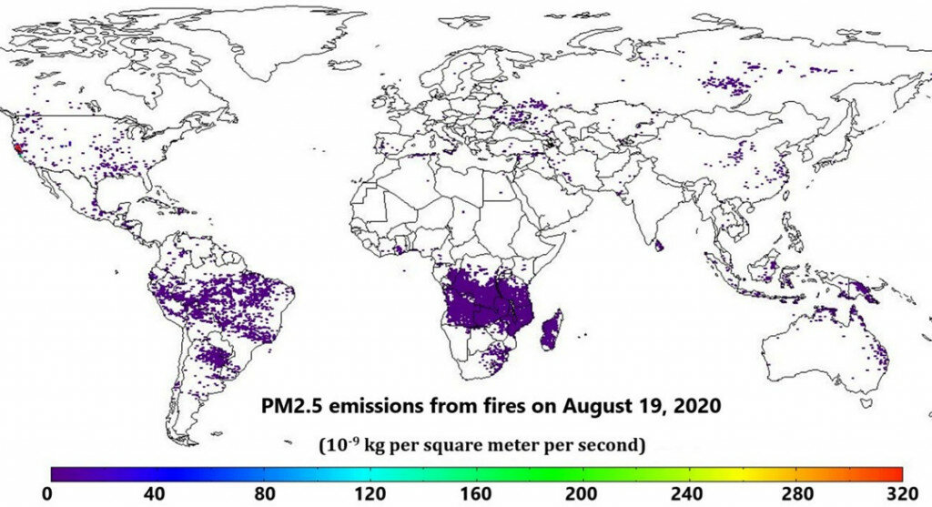
BROOKINGS – Wildfires in California have burned more than 4 million acres to date, more than double the previous record for the most land burned in a single year in the state.
Smoke from these fires has prompted air quality alerts in California, New Mexico, Nevada, Oregon, Idaho and Colorado – with plumes reaching as far as the Midwest this summer.
To predict the impact wildfires have on air quality and climate, Professor Xiaoyang Zhang of South Dakota State University’s Geospatial Sciences Center of Excellence uses satellite images to model emissions from these fires.
“It’s like a weather forecast, but it impacts human health,” Zhang said. “If an area will be subject to lots of smoke, people who have asthma and other health problems should avoid going outside.”
The data is also beneficial to firefighters and to meteorologists because the emissions affect the weather.
“It improves their capability to make accurate forecasts,” Zhang pointed out. The model also helps track carbon emissions from fires that contribute to global warming.
Zhang began working on global biomass burning emissions from wildfires at the National Oceanic Atmospheric Administration in 2005. Since coming to SDSU in 2013, he has received $1.15 million from NOAA for biomass burning emission and vegetation seasonal dynamics research.
The biomass burning emissions model calculates how much biomass is burning daily and provides hourly data on the aerosols released from the fires, Zhang explained. NOAA then incorporates the data into regional and global air quality models that forecast where the aerosols will drift and what areas will be affected, nationally and globally.
Through a new three-year, $310,000 NOAA grant, Zhang and postdoctoral research associate Fangjun Li will use real-time data from new-generation geostationary and polar-orbiting satellites to improve the accuracy of the biomass burning emissions product across the contiguous United States.
New satellite instrumentation gathers data more frequently and at a higher spatial resolution, Zhang explained. Spatial resolution refers to how much ground, or surface area, one pixel in the satellite image covers and therefore determines how detailed the picture is.
For example, to cover the globe, the model uses data from three geostationary satellites, which orbit the earth every 24 hours in the same direction as the Earth rotates. These satellites previously observed fires every half hour with a 4-kilometer resolution, but can now deliver data every 10 to 15 minutes globally and every 5 minutes in the United States with a 2-kilometer pixel resolution. This allows scientists to observe fires as small as 25 acres.
Furthermore, the images from new polar-orbiting satellites now provide data twice a day and have a 375-meter resolution, making it possible to detect fires as small as 0.05 acres, Zhang said. By blending data from multiple satellites, “we can estimate fire emissions every half hour for the United States and the product that once produced data once a day can do so every six hours.”
Handling the larger datasets will be challenging.
“We will need to develop a very powerful, robust algorithm and computer code to process the data,” he said.
Once SDSU researchers complete their work, Zhang will send the computer code and algorithm to NOAA, which generates the operational product with a latency less than six hours.
With the number of wildfires increasing, accurately modeling emissions and their impact on air quality can play a critical role in protecting human health.


